TosCAD directly connects your Total Station or GNSS receiver to your preferred CAD software by adding a comprehensive toolbar.
With just one click, TosCAD triggers a measurement and transfers the readings to your CAD program. You can watch your CAD models grow measurement by measurement.
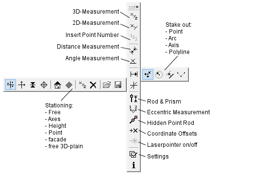
To stake out points, axes, circles or polylines, just click on the elements in your CAD drawing and TosCAD guides you to your destination in both, position and elevation.
TosCAD provides convenient options for stationing. For example, using Free Stationing you can position your instrument at an optimal location at your construction site.
TosCAD features a modular approach: You only pay for the functions you really need!
TosCAD works with many measuring instruments and CAD systems of all leading manufacturers.
|
Top Features:
Measures directly to your CAD software in 2D and 3D
Stakes out directly from your CAD software
Performs Stationings directly from your CAD coordinates
Measures distances, angles and slopes in 2D and 3D
Features eccentric measurements and measurements with hidden point poles
Supports Windows XP, Vista, 7, 8, 10
|